Intelligent Machines
Social Surveillance Yields Smarter Directions
Phone app Waze uses real-time information shared by drivers to tweak its directions and traffic advice.
Most drivers will be familiar with the feeling that trying a slightly different route, or leaving a few minutes later, would have saved them time in traffic, and some may have tweaked a familiar route to test the notion. A free navigation app for smart phones called Waze performs such experiments at a grand scale by treating its users as road-going data probes.
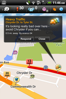
Waze users automatically broadcast their GPS position and speed to Waze over the Web at all times. Social-networking and gaming features built into the app also encourage them to actively share information such as the location of hazards and traffic jams. When a user asks the app for directions, those sources of information influence Waze’s routing algorithm. Users can see the position and speed of other users on a map, and also receive live hazard reports. The data collected by the app is used to refine Waze’s map in other ways, showing, for example, the location of unmapped streets.
“In the old world, you would flash your lights at someone. Now we can deliver the experience and intuition of other drivers to you through the app,” says Noam Bardin, the company’s CEO. Waze, which is based in Israel and Palo Alto, California, currently has more than 2.6 million users worldwide, roughly 800,000 of whom are in the U.S.
Waze awards points to drivers for miles driven with the app running, and also for submitting hazard reports. Making a report while driving, to indicate problems such as traffic jams, speed traps, or accidents, requires just three taps on the phone. Users can also create and join groups to follow reports from people who drive a particular route or area, or compete with friends to rack up the most points.
Those points do more than just make users feel good, says Di-Ann Eisnor, vice president and community geographer at Waze. “We use it as a confidence score for the contributions that user makes,” says Eisnor. A report of a traffic jam from a low-ranked user is less likely to change the route suggested by Waze than one from a high-ranked user, for example.
Social features like that are what really set Waze apart, says Alex Bayen, a researcher at University of California, Berkeley, whose group previously developed a phone app that simply collects traffic data. “There are many sources of traffic information but no other app lets you see other drivers around you and actively work together to post about traffic problems,” he says.
Most GPS navigation devices and apps that advise on traffic do so based on a mixture of historical traffic patterns and input from sparsely distributed road sensors, says Eisnor. Google’s free navigation app for Android phones combines users’ GPS trails with more traditional sources, although it offers fewer features than Waze.
“Unlike other apps, Waze is used a lot even when people don’t need to be told when to go, like for commuting,” Eisnor says. About 70 percent of trips made with Waze do not involve asking it for directions. Instead people leave it running on their phone to see real time traffic data, receive warnings of hazards reported by others and contribute themselves to the community.
The southwest-Florida TV station NBC-2 has created a Waze group for local commuters, and it now bases its reports exclusively on information and maps drawn from that community and other Waze users in the area. “They found that information from Waze was as good—and even better than—the paid-for traffic data they used before,” says Eisnor.
To encourage users to probe conditions in uncharted areas and thus extend Waze’s coverage, the company employs a game-like feature: icons dubbed “road goodies” placed on the map. Users earn points for driving over the virtual goodies, and often diverge from their route to do so, says Eisnor.
Mikel Maron, a developer and member of the board of Open Street Map, a collaborative project working to build a free, editable online map of the globe, says he can understand why users might be willing to change their route to gather data that helps others. Some of the data collected by Open Street Map is used by Microsoft’s Bing Maps service.
“I know that once people start mapping in Open Street Map, it becomes a kind of addiction. You really want to help fill in the white spaces,” says Maron. “I imagine that is perhaps how someone would feel about helping others by improving Waze’s coverage.” However, he says some people may reconsider when it becomes clear that Waze seeks to make money using their data.
One revenue strategy under development at the company involves placing virtual coupons or discounts on the road for collection. “We’re currently experimenting to see what influences behavior and find out what incentives work,” says Eisnor. “We’ve been surprised by what the threshold is.” Waze’s advertising platform launched in Israel two months ago. A recent trial in San Francisco awarded free concert tickets to the user who drove over the most promotional goodies.
Eisnor says that saving money can coexist alongside more altruistic motivations like helping to cut travel frustrations. “In time, I want to answer the question of whether we can reduce congestion based on coupons at Starbucks,” she says.
Bayer says he thinks that advertising and fixing traffic jams could go together. “I think it would be possible in future to use personalized incentives to try and decongest freeways by altering drivers’ routes,” says Bayer, “the driver and promoter might get something out of it but there can also be a public good.”
