Intelligent Machines
Tracking Hurricanes
New technologies are helping to amp up bad-weather tracking.
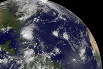
To monitor Hurricane Irene, NASA is relying on its bevy of satellites. The Tropical Rainfall Measuring Mission (TRMM) has been in orbit around Earth since 1997 and is equipped with infrared, microwave, and radar to measure rain. TRMM also transmits cloud heights, eyewall data, and data on lightning—useful because hurricane eyes often do not have lightning. The NASA Terra satellite snaps visible images of the hurricane, while NOAA’s GOES-13 satellite shows a larger image of the hurricane’s 600-mile wide cloud cover. NASA’s Aqua satellite snapped infrared images Friday morning to show where the coldest, strongest thunderstorms are within the hurricane.
NOAA is also using its WP-3D aircrafts to gather real-time weather data using onboard instruments and by dropping sensors into the storm to gather precipitation, wind, and thermodynamic data.
While satellites and manned aircraft have been extremely useful in gathering storm data, scientists want to get closer to the action without putting people in harm’s way. Last year as Hurricane Earl poised a threat to the eastern coast of the U.S., NASA, the National Oceanic and Atmospheric Administration (NOAA), and the National Science Foundation (NSF) deployed an unmanned plane carrying two new NASA instruments to capture the most detailed measurements of a hurricane to date.
The unmanned hurricane chaser, called Global Hawk, soared above the hurricane to record horizontal wind vectors, lightning, and 3-D information about temperature and cloud vapor. It also dropped sensor cylinders, called dropsondes, into the storm. These devices record and transmit temperature, humidity, wind speed, and direction in 3-D as they dive through the hurricane. Data from the project—which was the largest hurricane monitoring endeavor yet—will take years to analyze. Scientists hope it will greatly help refine models for understanding and predicting hurricane paths and severity. .
The planes were not operational for hurricane surveillance this year, according to Paul Newman, a researcher at NASA. Rather, the planes will be deployed next year as part of the NASA Hurricane and Severe Storm Sentinel mission. The mission will send two Global Hawks, capable of flying at 65,000 feet for 28 hours with a 1,500-pound payload, for a month during the hurricane seasons until 2014. Each will be equipped with different sensors, including the dropsondes, LIDAR, and a conically scanning Doppler radar.
Related Hurricane Coverage:
A Model for Hurricane Evacuation