Sustainable Energy
Volunteers See Fukushima Radiation on the Move
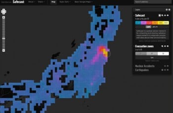
Crowd-sourced data provides a high-res view of radiation levels in Japan.
The radiation-mapping project launched shortly after the Fukushima Daiichi nuclear disaster recently surpassed more than ten million data points, all gathered by a network of local volunteers.
The maps show, among other things, that radiation levels are dropping more quickly than should be expected via half-life decay alone. Project director Sean Bonner says this may be a sign that radioactive contamination is on the move. “This could mean that organic material (such as leaves on tree, brush) might have been contaminated and fallen off and washed away over the last two years, lowering the overall background of an area,” he said in an email.
The project, Safecast, was founded one week after the disaster to share information about radiation levels around Japan. Although the Japanese government provides its own statistics on this issue, its data is sometimes unreliable and can be restricted from public access. Safecast sends volunteers cheap Geiger counters, called geigies, to measure local levels of radioactivity. Volunteers can either purchase a unit for anywhere from $200 to $1000 or build their own using a $450 kit. This data is then mapped and made publicly available through the Safecast website.
Over more than two years of data collection, Safecast has produced the highest resolution picture to date of Japan’s radiation levels. The project’s maps confirm that the majority of the country’s radiation levels remain near background, with no appreciable change in radioactive activity. In areas that do have significant radiation, the maps show how levels can fluctuate simply when one crosses the street in a given neighborhood—uncovering small, previously unrecognized hotspots, though the organization maintains that these hotspots are not cause for concern.
Safecast plans to continue collecting data to use in a larger analysis of how these levels change in different cities over the coming years. They hope to uncover more about where the radiation is spreading, and how a given area’s climate, topography, and soil affect the way surface radioactivity decays.